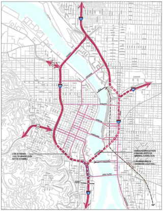
Map of Portland’s inner-city freeway loop. The 2005 Freeway Loop Advisory Group study proposed relocating the dashed segments into tunnels. (Source: the 2005 Freeway Loop Study.)
The year was 2005, and the tone was urgent.
“Clearly, the I-5/405 Freeway Loop needs immediate attention.”
“To keep the I-5/405 Freeway Loop viable, planning and design for improvements must begin now.”
“We are at a very critical juncture. It’s time to move forward.”
The blue ribbon Freeway Loop Advisory Group (FLAG), appointed by former Portland Mayor Vera Katz and Oregon Department of Transportation Director Bruce Warner, was tasked with finding strategies to surmount the increasingly apparent flaws of the inner-city’s post-World-War II freeway plan. The FLAG included representatives from ODOT, the Portland Business Alliance, the Oregon Trucking Association, TriMet, the Oregon Transportation Commission, and Metro.
This group—hardly a bunch of radicals— noted that “freeway construction, combined with urban renewal projects, divided and destroyed neighborhoods in the name of a modern transportation system.” To begin to remedy this, and to insure a prosperous future for our region, they proposed the very bold plan of removing the Marquam Bridge and relocating the southern and eastern portions of the Freeway Loop into tunnels. “Complex transportation projects can take at least 15 years from initiation to completion,” which is why they urged the planning to begin “now” (the study tends to bold the twelve occurrences of the word “now”).
Sixteen years later, where has our boldness gone?
Advertisement
With federal money finally available to correct, or at least mitigate, the worst mistakes of the freeway-building era, has our vision and urgency shrunken to the point that ODOT’s only proposal to fix the Freeway Loop is a misguided plan to widen I-5 through Albina, a community still hurting from the original freeway placement?
President Biden’s transportation plan notes that “too often, past transportation investments divided communities.” I say, let’s apply for federal money to actually reconnect our city.
The FLAG study was followed ten years later by the West Quadrant Plan. The West Quadrant Plan was more of a roadmap for future growth on the westside, and it replaced talk of tunnels with the more feasible idea of capping sections of I-405.
Both plans identified some of the same problem areas and traffic patterns which continue to create barriers in the city. Here are a few:
The southernmost stretch of I-405, between the Ross Island Bridge and Highway 26W interchanges creates a

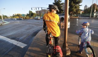
Bicycle riders wait to cross SW Broadway amid the chaos of I-405 and its ramps.
(Photo: J. Maus/BikePortland)
“significant barrier between the downtown and PSU area north of the freeway and the South Portland hills, particularly for pedestrians and cyclists. Growth in traffic … has also exposed the limitation in the freeway design, leading to congestion, short weaves and overreliance on local (and previously local) streets to carry regional traffic … ODOT identifies this stretch of the freeway system as being in the top tier in terms of number and severity of crashes.” (West Quadrant Plan)
I wish I could edit their quote and substitute “Southwest Corridor” for “South Portland hills,” because I-405 and the surface roads of 26W create an almost impenetrable divide between the entire area of southwest Portland and the central city, especially for people walking and biking.
Access to the river should be improved.
“The current Freeway Loop presents a number of barriers to river access from adjacent districts. These barriers include the long distances between crossings, the quality of the crossings, and freeway visual and noise impacts. Future project alternatives should include improved access and reduction in these barriers.” (FLAG)
The Freeway Loop hinders high-quality urban development.
“Portland is well known for its innovative urban planning and pedestrian friendly developments. But the Freeway Loop creates barriers that hinder commercial, recreational, and residential development and limits access to the river.” (FLAG)
The Freeway Loop Study mentions that there are 45 on- and off-ramps in the 6.5 loop. That is about seven dangerous, surface-street-disrupting intersections per mile. If some of them were removed it would improve safety on the surface streets and make designing bike lanes simpler. (Do we really need westbound exits off I-405 to SW 12th, 6th and 4th Avenues?)
Portland does not have a shortage of projects or plans which can begin to remedy the historic division and destruction of neighborhoods brought by the Freeway Loop. To this day, the Loop creates barriers which inhibit the flourishing of our city. The Biden infrastructure plan includes billions of dollars “for a new program that will reconnect neighborhoods cut off by historic investments.” This federal money might be a once in a lifetime opportunity. We should not squander it by being too timid.
— Lisa Caballero, lisacaballero853@gmail.com
— Get our headlines delivered to your inbox.
— Support this independent community media outlet with a one-time contribution or monthly subscription.
"urgent" - Google News
July 23, 2021 at 12:18AM
https://ift.tt/2V7eLXU
Opinion: 16 years after Portland’s ‘urgent’ Freeway Loop study, where has our boldness gone? - BikePortland.org
"urgent" - Google News
https://ift.tt/2ya063o
https://ift.tt/3d7MC6X
urgent
Bagikan Berita Ini


0 Response to "Opinion: 16 years after Portland’s ‘urgent’ Freeway Loop study, where has our boldness gone? - BikePortland.org"
Post a Comment